Aerial Photography Report
: Analysis on the Market, Trends, and TechnologiesThe aerial photography market is at a decisive pivot where scale of data assets now outvalues sheer capture capacity: there are 7,103 companies active in the topic, a signal of broad participation and fragmentation. Market forecasts show sustained double-digit expansion, with analysts projecting market growth at a CAGR around 12–16% across multiple reports, driven by UAV adoption, AI analytics and demand for survey-grade deliverables Aerial Imaging Market Report. The immediate implication is that firms which own time-series imagery or can convert captures into urgent, industry-specific outputs (insurance, utilities, construction) will capture margin expansion while pure image-for-hire providers face price compression.
This report was last updated 52 days ago. Spot an error or missing detail? Help us fix it by getting in touch!
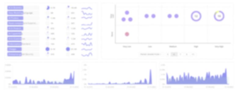
Topic Dominance Index of Aerial Photography
To identify the Dominance Index of Aerial Photography in the Trend and Technology ecosystem, we look at 3 different time series: the timeline of published articles, founded companies, and global search.
Key Activities and Applications
- Precision agriculture — field mosaics, NDVI/biomass indices, and plot-level phenotyping used to guide input scheduling and harvest decisions; platforms automate sample extraction and seasonal analytics.
- Infrastructure inspection & predictive maintenance — thermal and high-resolution visual passes for power lines, solar farms and pipelines; inspections combine radiometric thermography and automated anomaly scoring to reduce downtime and crew risk.
- Surveying, mapping and geospatial engineering — production of orthomosaics, DSM/DEM and survey-grade CAD deliverables to civil engineering tolerances; human-in-the-loop processing remains a commercial differentiator for certified outputs.
- Environmental monitoring and disaster response — rapid post-event mapping, habitat monitoring, and coastline change detection driven by multi-platform acquisitions (drone + manned + satellite) and repeat archives.
- Media, film and real-estate content — low-altitude cinematic captures, FPV filming and 360° virtual tours for marketing and production; these applications emphasize speed, aesthetics and regulatory compliance for commercial shoots.
Emergent Trends and Core Insights
- From capture to continuous data products — customers increasingly buy recurring, indexed data (tiles, time series, analytics) rather than one-off flights; this supports subscription and DaaS-style revenue models and increases lifetime value for suppliers.
- Sensor fusion is standard practice — visible + multispectral + thermal and LiDAR combinations are moving from bespoke projects to standard offerings for asset inspection and precision agronomy, improving decision fidelity in heterogeneous environments.
- Operational certification unlocks large contracts — formal operator authorizations (e.g. LUC, BVLOS permits) act as durable barriers; firms that secure these permissions win long-distance utility and national mapping work.
- Edge compute and on-platform triage reduce data drag — performing initial detection and filtering on the aircraft lowers bandwidth and speeds actionable delivery for time-sensitive clients (public safety, oil & gas).
- Historical imagery is a defensive moat — legacy aerial archives and orthorectified time series provide unique value for insurance, land-use litigation and environmental baselines and are monetizable beyond single capture events Nationwide Environmental Title Research.
Technologies and Methodologies
- Structure-from-Motion (SfM) photogrammetry and refined flight-schemes — mission parameters (altitude, lateral/longitudinal overlap) remain determinative for final DSM/orthomosaic accuracy; best practices yield sub-centimetric outcomes when combined with GCP/PPK workflows Unmanned Aerial Vehicle Photogrammetry Assessment.
- Radiometric thermal mosaics and calibrated OGI — radiometric workflows that preserve temperature metadata enable quantitative diagnostics for energy assets and environmental monitoring.
- LiDAR + photogrammetry fusion — combining dense point clouds with high-resolution imagery improves vertical accuracy and façade detail for urban 3D models and infrastructure assessments.
- Human-in-the-loop QA for survey deliverables — certified photogrammetrists and ASPRS-grade QA in processing pipelines convert drone captures into CAD/CIVIL deliverables faster and with lower rework risk, enabling premium pricing for engineering clients Aerotas.
- Autonomous VTOL and drone-in-a-box deployments — automated repeatable sorties and tethered solutions expand operating windows and lower per-mission OPEX for infrastructure programs.
Aerial Photography Funding
A total of 175 Aerial Photography companies have received funding.
Overall, Aerial Photography companies have raised $1.4B.
Companies within the Aerial Photography domain have secured capital from 451 funding rounds.
The chart shows the funding trendline of Aerial Photography companies over the last 5 years
Aerial Photography Companies
- Airpelago — A Nordic specialist that substitutes helicopters with autonomous drone fleets for long linear inspections of power lines; its platform emphasis on certified LUC operations and automated processing allowed it to win large utility contracts and scale repeatable inspection routes, demonstrating the commercial value of regulatory compliance and mission automation.
- aerialPLOT — Focused on agricultural research cohorts, this software-centric startup automates plot-level statistics from aerial imagery and integrates time-series analytics for trial managers; its human-verified extraction workflow converts imagery into publishable experimental data rapidly, reducing manual scoring effort for field trials.
- AeroGlobe — An Australian photogrammetry research firm that combines DSM/3D modelling with machine learning for marine and coastal geomorphology studies; its niche focus on validated elevation products and coastal change detection positions it to win government and conservation contracts that require scientifically defensible outputs.
- AERVIDEO — An unconventional capture method using a throwable foam rocket to lift action cameras where drones are restricted; its low-regulation, portable approach offers a legal and tactical alternative for extreme sports productions and some industrial shots, enabling creative captures without typical UAV constraints.
- Vintage Aerial — Owner of a massive historical archive (tens of millions of images) that sells time-series orthophotos and change detection products; for insurance, land-title and environmental baseline projects the archive acts as a non-replicable asset with persistent demand.
Identify and analyze 7.5K innovators and key players in Aerial Photography more easily with this feature.
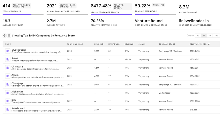
7.5K Aerial Photography Companies
Discover Aerial Photography Companies, their Funding, Manpower, Revenues, Stages, and much more
Aerial Photography Investors
TrendFeedr’s investors tool offers a detailed view of investment activities that align with specific trends and technologies. This tool features comprehensive data on 481 Aerial Photography investors, funding rounds, and investment trends, providing an overview of market dynamics.
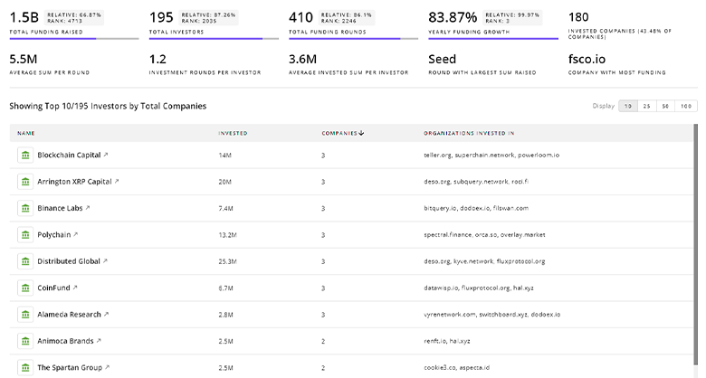
481 Aerial Photography Investors
Discover Aerial Photography Investors, Funding Rounds, Invested Amounts, and Funding Growth
Aerial Photography News
Stay informed and ahead of the curve with TrendFeedr’s News feature, which provides access to 3.8K Aerial Photography articles. The tool is tailored for professionals seeking to understand the historical trajectory and current momentum of changing market trends.

3.8K Aerial Photography News Articles
Discover Latest Aerial Photography Articles, News Magnitude, Publication Propagation, Yearly Growth, and Strongest Publications
Executive Summary
Aerial photography has shifted from a capture-centric market to one where data durability and analytic convertibility set winners apart. service providers that pair certified acquisition (BVLOS/LUC), multi-sensor fusion, and rapid, certified processing pipelines will extract the most value. Equally, operators that monetize archives and offer verticalized analytics (insurance, utilities, agriculture) can maintain pricing power despite commoditization of capture equipment. For practitioners, the priority is clear: invest in operational permissions, embed quality control and certified processing, and productize repeatable, subscriptionable data products rather than competing on single-flight price alone.
Interested in enhancing our coverage of trends and tech? We value insights from experts like you - reach out!