Aerial Imagery Report
: Analysis on the Market, Trends, and TechnologiesThe aerial-imagery market is moving from pure capture to packaged intelligence, driven by AI analytics, multi-sensor fusion, and new large-area collection methods; this shift sits on an ecosystem of more than 2,082 companies and $7.74 billion of cumulative funding in the topic area, signaling scale and investor interest DataHorizzon Research.
Key takeaway: customers now buy answers, not pixels — providers that combine frequent, high-resolution collection with cloud analytics and automated delivery (API/subscription) capture the largest value pools.
This report was last updated 109 days ago. Spot an error or missing detail? Help us fix it by getting in touch!
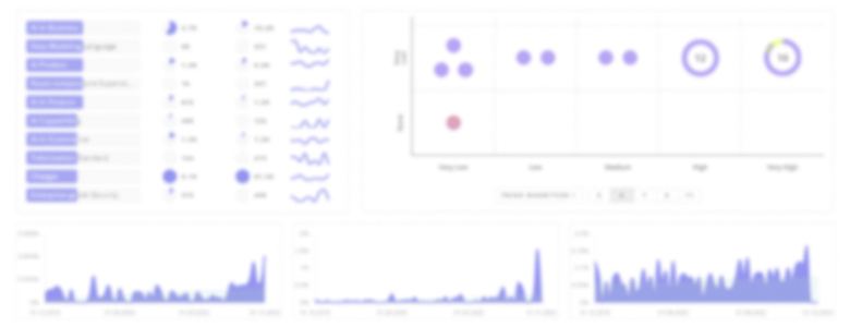
Topic Dominance Index of Aerial Imagery
To identify the Dominance Index of Aerial Imagery in the Trend and Technology ecosystem, we look at 3 different time series: the timeline of published articles, founded companies, and global search.
Key Activities and Applications
- Geospatial mapping and orthomosaic production for urban planning, cadastral updates, and GIS layers; frequent revisits and centimeter-level orthos drive municipal and utility use thebusinessresearchcompany – 2025.
- Precision agriculture: multispectral and thermal flights for NDVI, irrigation optimization, pest early-warning and yield prediction; service models target growers with subscription analytics.
- Construction, mining, and infrastructure inspection: volumetrics, progress tracking, and structural defect detection using oblique + vertical captures and automated change reports.
- Emergency response and disaster assessment: rapid on-demand acquisitions (drone and satellite) for damage triage, insurance claims, and logistics planning.
- Energy and utilities inspections: thermal and LiDAR-enabled surveys for solar, wind, and grid assets to reduce manual risk and speed preventive maintenance.
Emergent Trends and Core Insights
- AI as the primary differentiator — automated object detection, change detection, and predictive scoring convert imagery into recurring SaaS revenue and raise switching costs for customers.
- Growing importance of oblique capture and 3D/DTM outputs for digital twins and city modeling; clients pay a premium for accurate 3D models and integrated BIM workflows.
- Sensor fusion (RGB + multispectral + thermal + LiDAR) becomes standard for high-value verticals (energy, infrastructure, forestry); single-sensor offerings face commoditization.
- New collection models: large drone fleets, drone-in-a-box (persistent ops), and high-altitude/stratospheric platforms enable lower marginal cost for area coverage and more frequent revisits, altering unit economics for mapping programs futuremarketinsights – 2025.
- Business model shift to subscription and API delivery: buyers prefer continuous, indexed datasets plus analytics over one-off flights; this supports higher LTV and predictable revenue fortunebusinessinsights – 2025.
Technologies and Methodologies
- Unmanned Aerial Vehicles (multirotor, fixed-wing, hybrid VTOL) for flexible mission profiles and cost-effective small-area capture marketresearch – 2025.
- LiDAR and airborne laser scanning for accurate 3D point clouds and under-canopy models; LiDAR increasingly paired with photogrammetry for complete models.
- Multispectral and hyperspectral imaging for agronomic indices, mineral mapping and environmental monitoring.
- Edge compute on UAVs and secure, cloud-native pipelines for low-latency stitching, on-the-fly analytics and scalable delivery (APIs, tile services) researchandmarkets – 2025.
- Photogrammetry, Structure-from-Motion (SfM) and automated orthorectification workflows that reduce need for ground control points in many use cases marketresearchfuture – 2025.
- Radiometric thermal mapping and georectified thermal orthomosaics for energy audits, solar-panel and building inspections.
Aerial Imagery Funding
A total of 218 Aerial Imagery companies have received funding.
Overall, Aerial Imagery companies have raised $7.9B.
Companies within the Aerial Imagery domain have secured capital from 776 funding rounds.
The chart shows the funding trendline of Aerial Imagery companies over the last 5 years
Aerial Imagery Companies
- FlyPix AI — FlyPix AI pairs multispectral drone captures with automated agronomic analytics, selling grower-level subscription products rather than single flights. The company focuses on no-code dashboards and predictive crop alerts for mid-sized operations, positioning itself for rapid user expansion in regions where service pricing replaces hardware purchase.
- Readar — Readar combines object-detection models with frequent oblique captures to produce property-level condition and roof-damage scores for insurers and property managers; it packages change alerts and indexed imagery as a recurring data service, targeting insurance workflows that need fast triage after events.
- SkyIMD — SkyIMD offers autonomous drone inspection fleets and a cloud inspection-management platform for utilities and large contractors; its value is operational continuity (automated scheduling, compliance logs) and edge pre-processing that shortens field-to-report cycles.
- FlyGuys — FlyGuys operates local drone-service marketplaces and standardized data-processing pipelines aimed at small B2B buyers (real estate, small farms). They lower adoption friction via fixed-price packages and integrated delivery of orthos and simple analytics.
Identify and analyze 2.6K innovators and key players in Aerial Imagery more easily with this feature.
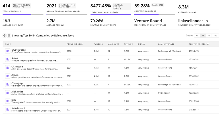
2.6K Aerial Imagery Companies
Discover Aerial Imagery Companies, their Funding, Manpower, Revenues, Stages, and much more
Aerial Imagery Investors
TrendFeedr’s investors tool offers a detailed view of investment activities that align with specific trends and technologies. This tool features comprehensive data on 938 Aerial Imagery investors, funding rounds, and investment trends, providing an overview of market dynamics.
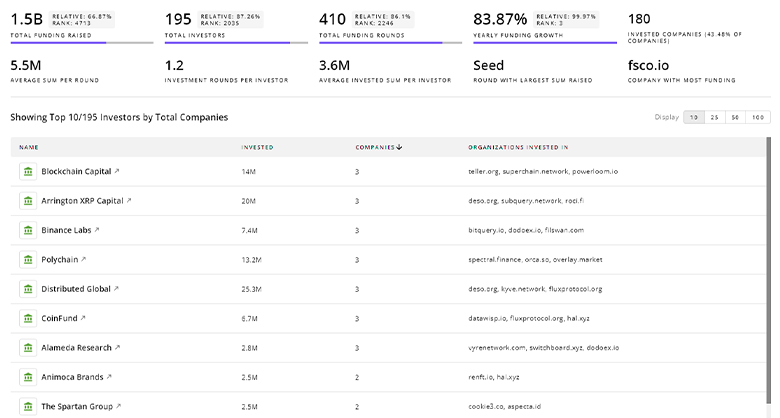
938 Aerial Imagery Investors
Discover Aerial Imagery Investors, Funding Rounds, Invested Amounts, and Funding Growth
Aerial Imagery News
Stay informed and ahead of the curve with TrendFeedr’s News feature, which provides access to 3.1K Aerial Imagery articles. The tool is tailored for professionals seeking to understand the historical trajectory and current momentum of changing market trends.

3.1K Aerial Imagery News Articles
Discover Latest Aerial Imagery Articles, News Magnitude, Publication Propagation, Yearly Growth, and Strongest Publications
Executive Summary
The business opportunity in aerial imagery now concentrates where data frequency, sensor richness, and automated analytics intersect. Providers that integrate capture (affordable, repeatable collection), multi-sensor fusion (optical, thermal, LiDAR), and cloud-delivered intelligence (APIs, subscriptions, domain-specific models) will win durable contracts across government, energy, insurance and agriculture. Given the dispersion in published forecasts, strategy should prioritize a clear monetization path: convert one-time flights into recurring data products, secure long-term collection rights (or own collection fleets/platforms), and embed analytics into buyer workflows to create defensible revenue streams.
Interested in enhancing our coverage of trends and tech? We value insights from experts like you - reach out!