Arcgis Report
: Analysis on the Market, Trends, and TechnologiesThe ArcGIS ecosystem sits at the intersection of an expanding market and a consolidating partner network: ArcGIS–centric activity shows 1168 companies addressing the platform and total funding raised: $5.17B in the topic area, underscoring sustained capital flows into specialist services and data suppliers. Recent product and analytical upgrades (trend rasters, logistic trend surfaces, and expanded demographic variables) are enabling pixel-level forecasting and real-time enrichment for use cases from infrastructure resilience to public-health mapping. Market reports confirm strong demand for cloud and GeoAI-enabled spatial platforms, pushing enterprise customers toward hybrid cloud ArcGIS deployments and specialist data-capture partners.
This report was last updated 193 days ago. Spot an error or missing detail? Help us fix it by getting in touch!
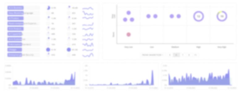
Topic Dominance Index of Arcgis
To identify the Dominance Index of Arcgis in the Trend and Technology ecosystem, we look at 3 different time series: the timeline of published articles, founded companies, and global search.
Key Activities and Applications
- Enterprise Cloud Migration and ArcGIS Enterprise Management — Large public utilities and municipal programmes move ArcGIS deployments into cloud or hybrid topologies to scale analytic workloads and enable collaboration; specialist system integrators now package ArcGIS Enterprise as a managed cloud service to reduce internal IT burden (ROK Technologies provides cloud-first ArcGIS engineering and managed services) ROK Technologies, LLC.
- Spatial Trend Surface Modeling and Forecasting — Practitioners generate continuous trend rasters (intercept, slope, higher-order bands) and use logistic variants for binary risk mapping (species presence, hazard/no-hazard), enabling automated scenario pipelines with downstream prediction functions.
- High-fidelity Data Capture for Digital Twins — Aerial LiDAR, photogrammetry, and multi-sensor fleets create base layers for 3D city models and digital twins used in infrastructure monitoring and construction coordination; independent aerial providers supply proprietary libraries that reduce survey cycle time (Barr GeoSpatial Solutions leads large-scale LiDAR acquisition) Barr GeoSpatial Solutions.
- Field AR and 3D Workflows — Augmented reality and 3D documentation are migrating into field operations for subsurface utility projects and construction QA; AR field apps that integrate with ArcGIS and BIM accelerate on-site decisions and reduce rework (vGIS Inc. integrates AR, AI, and ArcGIS for jobsite coordination) vGIS Inc..
- Demographic Enrichment and Location Intelligence — New demographic variable sets and DemoStats forecasts are embedded as enrichment services to support retail site analysis, public-health outreach, and market segmentation within ArcGIS pipelines Esri Blog – What’s New Esri Demographics (June 2025).
Emergent Trends and Core Insights
- Platform Consolidation with Specialist Value Chains — The ArcGIS platform serves as the de facto integration layer while a fragmented field of niche vendors captures last-mile value (data capture, AR, EAM/BIM integrations); buyers increasingly prefer certified ArcGIS partners for vertical use cases Geographic Information System Market Report.
- Pixel-level Temporal Modeling — Multidimensional trend rasters (multi-band time coefficients) permit per-pixel forecasting and efficient application of ML models to time series, shifting workflows from ad-hoc snapshots to continuous monitoring for urban growth and environmental variables Generate Trend Raster.
- GeoAI & Natural-Language Interactions — Cloud GeoAI and embedded AI assistants are lowering the barrier to spatial analytics, enabling non-specialists to ask natural-language questions and obtain enriched spatial outputs; vendors and platform vendors are packaging GeoAI toolchains into managed services Esri + Cloud Partnerships.
- 3D/Digital Twin Norms for Infrastructure — The sector is shifting investment from 2D maps to 3D models and digital twins for asset lifecycle management; procurement increasingly specifies centimeter-grade datasets and continuous update pipelines supported by LiDAR and photogrammetry Mordor Intelligence – APAC GIS Market.
- Sustainability and Contracting — Environmental monitoring, carbon accounting, and ESG reporting are embedded into contract requirements for public infrastructure work; geospatial workflows now appear in RFPs as compliance and reporting mechanisms, favouring providers that can demonstrate audited environmental metrics Geospatial Analytics Use Cases.
Technologies and Methodologies
- Spatial Analyst Trend Tools & Multidimensional Rasters — Polynomial and logistic regression trend surfaces (intercept, slope, higher orders) form the backbone for continuous surface modeling and binary probability mapping; residuals and banded coefficients support automated validation and downstream prediction Trend (Spatial Analyst)—ArcGIS Pro.
- ArcGIS Enterprise + Managed Cloud Architectures — Enterprise deployments migrate to hybrid cloud patterns combining scalability with data-sovereignty controls; managed ArcGIS cloud services reduce operational friction for large public utilities and municipal clients Cloud GIS Market Signals.
- GeoAI and Embedded ML Pipelines — Deep learning toolsets inside ArcGIS Pro, automated feature extraction from imagery, and model inference on trend coefficients enable operational predictive tasks (vegetation growth, infra decay) and feed decision rules for asset management ArcGIS Pro Deep Learning Tools.
- BIM↔GIS and EAM Integrations — Tight coupling between BIM models, ArcGIS 3D scenes, and Enterprise Asset Management (IBM Maximo, Cityworks) drives lifecycle workflows from design to operations; middleware and connectors are now a procurement line item for infrastructure contracts ActiveG.
- Field AR + Reality Capture — AR overlays tied to high-precision GNSS and point clouds let field crews execute guided tasks, document conditions, and perform QC in situ; these capabilities reduce rework and shorten inspection cycles (vGIS, Argis Solutions extend ArcGIS into AR workflows) Argis Solutions, Inc..
Arcgis Funding
A total of 82 Arcgis companies have received funding.
Overall, Arcgis companies have raised $5.2B.
Companies within the Arcgis domain have secured capital from 309 funding rounds.
The chart shows the funding trendline of Arcgis companies over the last 5 years
Arcgis Companies
- GISCARTA — GISCARTA provides a no-code, web GIS platform that targets rapid deployment for urban planning and transport analyses; the company packages prebuilt analytical dashboards that reduce the need for specialist GIS developers and support faster time to insight for municipal and mid-market customers. Their approach addresses the skills shortage by shifting routine analysis into intuitive workflows while retaining exportable ArcGIS-compatible outputs.
- Dira GeoSystems — Dira GeoSystems spun out of an Esri local organisation to focus on high-precision data production and interactive editing ergonomics for ArcGIS Pro; they target national mapping agencies and large municipal datasets where QA/QC and cartographic refinement create measurable value. Their tools accelerate migrations to ArcGIS Pro by automating repetitive editing and verification tasks.
- GIS WebTech — GIS WebTech specialises in economic-development and site-selection web applications built natively on ArcGIS; by tailoring data schemas and visualization templates to investor attraction teams they create a defensible niche that serves councils and regional development agencies. Their stack emphasises secure hosted maps and rapid configuration for transactional procurement cycles.
- Aerosynergy Solutions Sdn. Bhd. — Aerosynergy focuses on automated drone surveying workflows and high-throughput data processing in Southeast Asia; by automating large portions of the capture → photogrammetry → GIS ingestion pipeline they lower per-hectare surveying costs for municipal and resource clients. This automation directly addresses procurement pressures in APAC smart-city and cadastral programmes.
- ArcGEO Information Systems — ArcGEO acts as the Esri representative in Slovakia and combines long-running local trust with ISO-accredited processes for utility and telco customers; their strength lies in regulated sectors that require certified data management and rigor in migration projects. Their longevity and formal quality control make them the preferred partner for risk-averse public clients.
Identify and analyze 1.2K innovators and key players in Arcgis more easily with this feature.
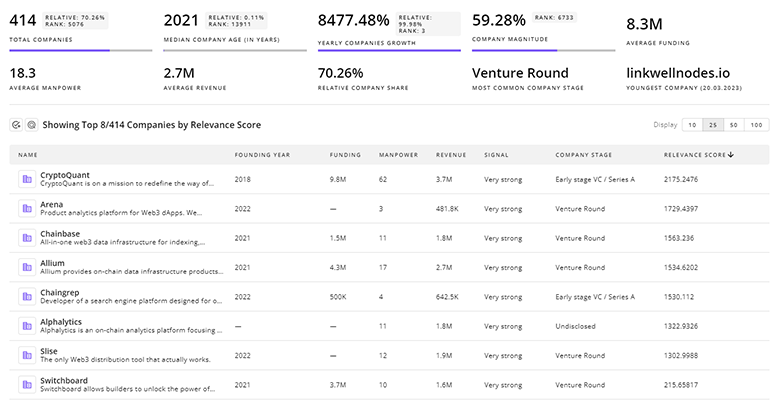
1.2K Arcgis Companies
Discover Arcgis Companies, their Funding, Manpower, Revenues, Stages, and much more
Arcgis Investors
TrendFeedr’s investors tool offers a detailed view of investment activities that align with specific trends and technologies. This tool features comprehensive data on 399 Arcgis investors, funding rounds, and investment trends, providing an overview of market dynamics.
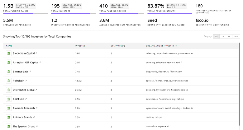
399 Arcgis Investors
Discover Arcgis Investors, Funding Rounds, Invested Amounts, and Funding Growth
Arcgis News
Stay informed and ahead of the curve with TrendFeedr’s News feature, which provides access to 2.6K Arcgis articles. The tool is tailored for professionals seeking to understand the historical trajectory and current momentum of changing market trends.
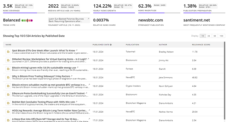
2.6K Arcgis News Articles
Discover Latest Arcgis Articles, News Magnitude, Publication Propagation, Yearly Growth, and Strongest Publications
Executive Summary
ArcGIS now functions less as a standalone product and more as the operating layer that unifies high-fidelity capture, cloud analytics, GeoAI, and operational systems. Market momentum sits with solutions that remove integration risk: cloud/hybrid ArcGIS deployments, verified data capture pipelines, and application-level extensions (AR, digital twins, EAM/BIM bridges). For buyers, the practical playbook is (1) procure verified base data and continuous update contracts rather than one-off surveys, (2) demand partner capabilities for ArcGIS Enterprise cloud management to reduce internal IT cost and project slippage, and (3) specify ML/GeoAI model validation and operational SLAs in procurement to ensure predicted outcomes become reliable operational inputs. Businesses that align staffing, procurement, and platform strategy to deliver repeatable, auditable spatial workflows will capture the majority of value as the market scales.
Interested in enhancing our coverage of trends and tech? We value insights from experts like you - reach out!