Satellite Imaging Report
: Analysis on the Market, Trends, and TechnologiesThe satellite imaging market is at an operational inflection where data cadence, in-orbit processing, and vertical analytics determine commercial value more than raw sensor count; the market recorded $4.2 billion in revenue in 2023 and is growing at a 11% CAGR, placing pressure on providers to convert imagery into time-sensitive intelligence rather than commodity pixels. Recent market analyses and company signals show accelerating investment in onboard AI, SAR persistence, and hyperspectral analytics, which together are compressing the capture-to-action timeline and reshaping buyer expectations.
150 days ago, we last updated this report. Notice something that’s not right? Let’s fix it together.
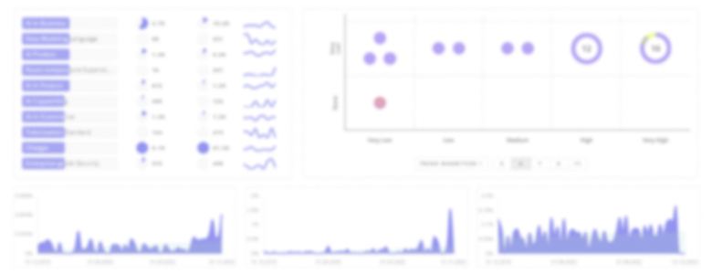
Topic Dominance Index of Satellite Imaging
To gauge the influence of Satellite Imaging within the technological landscape, the Dominance Index analyzes trends from published articles, newly established companies, and global search activity
Key Activities and Applications
- Precision Agriculture and Crop Monitoring — Frequent multispectral and hyperspectral revisits enable crop-level stress detection, yield estimation, and compliance verification for finance and insurance use cases.
- All-Weather Maritime and Infrastructure Surveillance (SAR) — Persistent Synthetic Aperture Radar (SAR) monitoring supports vessel detection, oil-spill response, and ground-movement surveillance where optical systems fail Commercial Satellite Imaging Market Outlook 2025.
- Disaster Response and Rapid Damage Assessment — Higher revisit cadence and automated change-detection pipelines are shortening response times for emergency managers and insurers Commercial Satellite Imaging Market Size, Share & Growth Trends.
- Ground Deformation and Critical-asset Integrity — InSAR services deliver millimeter-scale displacement metrics for mining, pipelines, and civil works, supporting preventive maintenance and regulatory compliance.
- Cloud-free Optical and Data Fusion for Continuous Monitoring — AI-based cloud removal and optical-SAR fusion create analysis-ready imagery feeds that expand commercial applicability to climate, forestry, and compliance uses.
Emergent Trends and Core Insights
- Onboard Edge Processing as a Differentiator — The patent and industry signals show a strategic pivot to performing triage, compression, and initial inference on-satellite to overcome downlink bottlenecks and reduce latency for time-critical users Global Satellite Data Services Market.
- VLEO and Near-Aerial Resolution Economics — Very-Low Earth Orbit (VLEO) concepts are being commercialized to deliver aerial-quality visible and thermal imagery at dramatically reduced latency; companies pursuing VLEO position themselves to replace some aerial survey spend Albedo.
- SAR + Optical Fusion for Reliable Intelligence — Customers increasingly demand fused products combining SAR persistence with optical spectral richness to remove single-sensor failure modes and ensure uninterrupted intel delivery Commercial Satellite Imaging Market Trends.
- Hyperspectral Move from R&D to Constellations — Hyperspectral smallsats are moving beyond demonstrations to commercial constellations, enabling material identification and emissions/health monitoring that standard multispectral sensors cannot provide.
- Ingredient-Provider Value Capture — The clearest durable business model emerging is specialization in indispensable processing capabilities (atmospheric correction, synthetic training data, automated SAR classification) that every imagery platform must adopt; such providers can license technology broadly and avoid the high-cost, low-margin upstream of satellite ownership.
Technologies and Methodologies
- Synthetic Aperture Radar (SAR) and InSAR — Multi-band SAR and operational InSAR pipelines are the foundation for all-weather persistence and millimeter displacement monitoring in infrastructure and geohazard applications sarmap.ch.
- On-board AI / Edge Computing — Modular payloads and lightweight neural networks enable initial object detection, cloud screening, and prioritized downlink to cut latency and bandwidth costs Space on-board Computing Platform Market.
- Hyperspectral Sensors and Metadata Hypercubes — High spectral resolution capture plus rich metadata structures allow per-pixel material classification, supporting mining, agronomy, and emissions work Pixxel.
- Cloudless Optical via AI Fusion — Machine learning approaches that reconstruct cloud-free optical composites from multi-temporal and SAR inputs raise effective optical uptime for monitoring use cases ClearSKY Vision.
- Digital Twins and 3D Reconstruction — Semantic 3D models built from fused satellite, aerial, and ground data enable simulation and asset management workflows for cities, defense, and autonomy Blackshark.ai.
Satellite Imaging Funding
A total of 242 Satellite Imaging companies have received funding.
Overall, Satellite Imaging companies have raised $14.4B.
Companies within the Satellite Imaging domain have secured capital from 1.0K funding rounds.
The chart shows the funding trendline of Satellite Imaging companies over the last 5 years
Satellite Imaging Companies
Simularity
Simularity provides an Automated Image Anomaly Detection System that flags unusual changes by comparing new imagery against historical baselines, enabling cost-efficient large-area monitoring using even lower-resolution satellite feeds. Their approach reduces the need for constant high-resolution tasking by directing expensive captures only where AI indicates an anomaly. This makes them a logical integration partner for platforms that need low-cost surveillance triggers across continental footprints.SaraniaSat
SaraniaSat focuses on hyperspectral analytics for agriculture, delivering diagnostic indicators for crop stress, nutrient deficits, and early pest/disease signals. The company packages hyperspectral processing into operational outputs that farm managers and agribusinesses can act on, addressing a growing demand for verification and finance-grade agricultural intelligence.RESOLV
RESOLV offers near-real-time atmospheric correction and surface reflectance conversion aimed at small satellite operators that lack large calibration infrastructures. Their processing returns analysis-ready data from constrained platforms, directly improving the commercial viability of new constellations by raising product quality without heavy hardware upgrades.SpecTerra Geospatial Imagery
SpecTerra combines airborne imaging expertise with high-resolution remote sensing services tailored for ecosystem assessment and vegetation mapping. By offering targeted, verticalized aerial workflows and ground-validated deliverables, they sit at the intersection of traditional aerial surveys and satellite monitoring—an advantageous position as customers demand complementary, high-fidelity datasets.PierSight
PierSight is building a maritime-focused SAR constellation with AIS integration to deliver persistent, vessel-level intelligence for shipping, insurance, and coastguard customers. Their specialization on ocean traffic and ship behavior analytics targets a monetizable niche where persistent, all-weather coverage maps directly to revenue (insurance underwriting, supply-chain risk).
Get detailed analytics and profiles on 1.2K companies driving change in Satellite Imaging, enabling you to make informed strategic decisions.
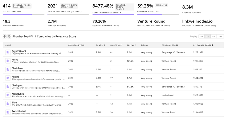
1.2K Satellite Imaging Companies
Discover Satellite Imaging Companies, their Funding, Manpower, Revenues, Stages, and much more
Satellite Imaging Investors
TrendFeedr’s Investors tool provides an extensive overview of 1.4K Satellite Imaging investors and their activities. By analyzing funding rounds and market trends, this tool equips you with the knowledge to make strategic investment decisions in the Satellite Imaging sector.
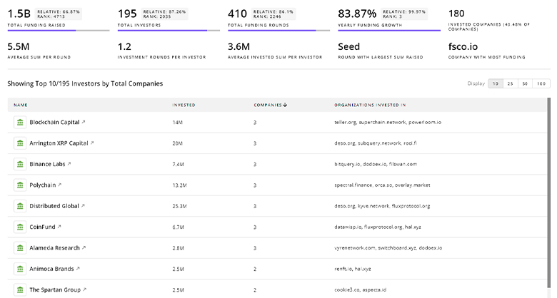
1.4K Satellite Imaging Investors
Discover Satellite Imaging Investors, Funding Rounds, Invested Amounts, and Funding Growth
Satellite Imaging News
Explore the evolution and current state of Satellite Imaging with TrendFeedr’s News feature. Access 1.7K Satellite Imaging articles that provide comprehensive insights into market trends and technological advancements.
1.7K Satellite Imaging News Articles
Discover Latest Satellite Imaging Articles, News Magnitude, Publication Propagation, Yearly Growth, and Strongest Publications
Executive Summary
Satellite imaging is maturing into an intelligence market where the high-frequency, multi-sensor product that arrives already analyzed to a decision threshold commands premium pricing. The data evidence points to a structural split: satellite ownership and data supply will become commoditized as launch economics improve, while differentiated, vertical analytics and indispensable processing primitives (onboard AI, atmospheric correction, SAR interpretation, hyperspectral feature extraction) will concentrate margin. Strategic priorities for commercial players are clear: secure recurring revenue via subscription intelligence products, integrate or partner with specialized processing "ingredient" providers, and localize processing to satisfy data-sovereignty and defense procurement constraints. Firms that align product design around actionable outputs and minimize latency between capture and decision will capture the disproportionate share of commercial value in the next market cycle.
We're looking to collaborate with knowledgeable insiders to enhance our analysis of trends and tech. Join us!